Old Lea County, N.M.

Category: history

  • Eugene Price

    Gene Price (full name Eugene Hubbert Price) was born on November 19, 1868, in Grayson County, Texas to Theodore Martin Price (1836 – 1927) and Martha Ann Virginia Drisella Hubbert Price (1842 – 1905). Theodore Martin Price was a farmer/rancher/merchant and also a circuit riding Methodist preacher. From his early years, Gene was keenly interested in ranching, beginning in the era of the open range.

    As a young man, he worked on several ranches in the southwest. He named the Quinn Brothers, the Hat Ranch, Pemberton Brothers and the E Ranch in his comments. In 1889, he married the former Lily Kirby Harris Cook in Eolian, Texas. Around 1901, the family homesteaded in New Mexico, at the corner where Yoakum, Gaines, Eddy, and Chaves counties met – roughly 15 miles east of the future site of Lovington.

    Mr. Price built up one of the area’s earliest high-quality registered Hereford herds. For a while, he leased the Highlonesome Ranch, and the family resided in its old headquarters house. As their children reached school age, the family bought a home in Lovington while still working the ranch. Gene served on the Lovington School Board and participated actively in community matters; he generously donated land for a second, larger school building, which served as the town’s only school for many years. He was a long time member of the Methodist Church in Lovington.

    In his later years, he authored “Open Range Ranching on the South Plains in the 1890’s,” a memoir of his early experiences that has become a valuable resource for those interested in the region’s history. Long out of print, the original publication included a reproduction of Gene’s informative hand drawn map of Lea County and the surrounding area.

    Mr. Price passed away on September 5, 1952. Mrs. Price died on October 16. 1962. Both are buried in Lovington Cemetery. In 1988, he was posthumously honored with a Bronze Cowboy award for his numerous contributions to the early traditions and settlement of Lea County.

    Image credit – Hobbs Daily News-Sun, August 13, 1967
  • David L. Minton’s Buckeye Pictures

    Many thanks to David L. Minton for sharing these photos with us. If you can help identify more of the people shown, please let us know.


    Names mentioned:

    Full names: Rosa Lee Ries, Betty Jo Cox, Betty Jo Williams, J. L. Ward, Mrs. Townsend

    First names: Sidney, Melvin, Don, Emma, Ernest, Wayne, Felton, Billy, Emma Jean, Randall, June, Joy, Bill, Glen, Dorothy, Meatha, Albert

  • A Reporter’s 1929 Carlsbad Cavern Visit

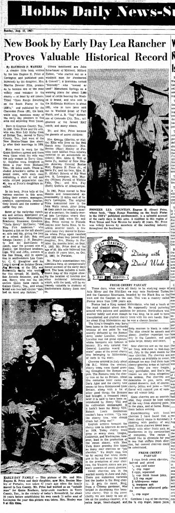
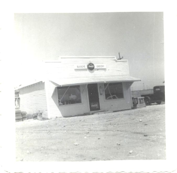
    Chances are, many readers have been to Carlsbad Caverns numerous times. Below is is an excerpt from reporter Alvin Rucker’s column “Across the Trail of Billy the Kid” in the July 6, 1929 issue of the McCurtain Gazette published in Idabel, Oklahoma:

    Tourists from Oklahoma who plan to drive over the Oklahoma City – Carlsbad Cavern route this vacation season should arrange travel schedule so as to reach Lubbock, Texas, at the end of the first day’s drive, and Carlsbad the second night. It is necessary to be at the cavern entrance at 10 o’clock a.m. in order to get through, for at that hour the “donters” start. The cavern is operated by the federal government. One daily trip is made through the cavern, about five hours being required. All go in a big mob, and for every 20 visitors there is one “donter.” It is the “donters’” business to go along and tell you to quit whatever you happen to be doing. It’s “don’t walk so fast;” “don’t walk so slow;” “don’t go in there;” “don’t touch the rocks;” “don’t carry away any of the formations.” When I got out of that cavern I was as obedient as a private in the Army. It is necessary for the guides continually to admonish the visitors in order to prevent accidents and to preserve the cavern in its pristine condition for succeeding generations. Much of the original beauty of Mammoth cave, Kentucky, been lost through wantonness on the part of visitors, and the government is wisely trying to preserve Carlsbad cavern. A portable typewriter ean not give even a hint of the awe-inspiring grandeur of the interior of Carlsbad cavern, and the best that I can do is to send you some pictures, but even photography is pitifully inadequate. The cavern is electrically lighted and trails are absolutely fool-proof. The great dining room where hot dinners are cooked and served is 650 feet under ground. It was the farthest I had ever been from heaven. The head guide pointed out a formation which, he said, had required 60,000,000 years to complete, after the cave was formed. A man from New York demanded a recount, but got no second. Sixty million years may a long time when compared with man’s allotment of three score and ten years on earth, but after all, 60,000,000 years is not even a sun-up in eternity. If Billy the Kid had known of that cave they wouldn’t have had him yet.

    Literature issued in connection with the cavern states that the ascent is so gradual and slow that even the aged need not fear becoming fatigued in making the trip. I noticed, however, that a white-haired old gentleman from Maryland who was making the trip the day I was in the cavern panted like a prize fighter in the last round he got half way through, and he gave up. Next day I saw him in Roswell and he was all right. He said that he wouldn’t have become tired but for the fact that he had asthma and heart trouble. He sorry that he was not able to go clear through the cavern. I told him that in a few more years they would be running ambulances through the cavern for invalids and that he could make the trip then. That cheered him up.

    Those who want to turn back before the journey is completed are permitted to do so with an escort at dining room, and the others go on. I stayed until the finish, but I had rather change four flat tires in a downpour of rain or beneath the burning sun of the Carrizozo desert than climb that last flight of 200 steps, after tramping for hours in the cavern. In coming out it is the last 1,000 miles that seems the hardest on old folks. Five hours is a long time to be out  of God’s sunlight, during daylight hours. It seems like eternity. When I got out, I hurried to Carlsbad, 30 miles distant, and bought all the newspapers I could find, in order to see what had happened on earth while I was underground – it seemed so long. The dining room is operated as a private concession. The meals are cooked down there and there is a telephone in the dining room. The meals cost 75 cents and are worth the money. The cavern is probably the nearest bone-dry spot between the Rio Grande and the Canadian border.

    Carlsbad cavern is winter resort for to the millions of Oklahoma bats that make the caves of Major county their homes during the summer. Bats are great tourists, according to batologists, who say they are exceeded in prodigious flights only by wild geese and flivver owners.

    It is needless for Oklahomans to hasten to Juarez after visiting Carlsbad cavern, for they will be making and selling it in Juarez long after the vacation season is over. In Carlsbad, Juarez-bound tourists, pending the completion of the scenic cutoff, are directed to drive south to Pecos and then west to El Paso and Juarez, but if you take my advice you will do as Carlsbad citizens themselves do when they start to El Paso and Juarez – drive north to Roswell and then west over the highway scenic route. Stay in New Mexico as long as possible, not only because of the places of historical and topographical interest, but because of the wonderful highways. In New Mexico you pay 25 cents a gallon for gasoline, but the extra price goes on the highways, the tourist obtains more miles per gallon, and if time is an element he can drive 100 miles an hour, if his car will go that fast.

    Southern New Mexico is a tourist’s paradise. The serpent-like Rio Pecos, the noisy Ruidoso, the Bonito, the Hondo and Tularosa flow through it; the Capitans, the Guadalupe, Sacramento and the Sierra Blanca rise above it; white desert sands glisten in it and over all is the sunny mantle and atmosphere of Mexico and Spain.

    From Carlsbad drive 15 miles north on Highway No. 2 and stop at a lone filling station on the right side of the road. It is run by Frank Head of Konowa, Okla. Get Head to introduce you to John McKenzie, a cattle herder on the surrounding plains. McKenzie will be glad to take you up the road a few miles and show you the site of a forgotten adobe town and its abandoned cemetery – old Seven Rivers. Long before there was a railroad in New Mexico Seven Rivers was a boisterous cow town, and the hang-out for the Seven Rivers Warriors and L G. Murphy’s cowboys. Stage and freighters made old Seven Rivers a stopping place during the 15 years following the Civil war. Nothing remains now except the ruins of old adobe buildings, thousands of pieces of whiskey bottles, poker chips and revolver shells. John Dowe transported lumber on burros to old Seven Rivers and erected a frame saloon building. Among the adobe saloon buildings and other adobe houses the frame structure was so outstanding the knights and knaves of the plains literally shot it to pieces. McKenzie can tell you that there not a space that could be covered by the hand that was not perforated by revolver and rifle bullets. Have him take you to the old Seven Rivers cemetery, nearby, and you will see that the whooping, whiskey drinking, revolver shooting cowboys did not spare even the few tombstones when they were looking for targets.

    The Pecos valley was to the cattle covered plains, what the Nile valley is to Egypt – the most fertile and desired section, and hundreds of thousands of longhorns once grazed in the valley. The herds were owned by kings who paid no tribute; they were guarded by men who acknowledged no master and who knew no home except the saddle. Drive on north to Roswell, 60 miles, but when five miles south of Roswell turn to the right in a grove of cottonwood trees that leads to several brick houses. That is the the old South Spring ranch headquarters where old John Chisum, cattle king of the Pecos valley, once lived in medieval splendor. On burro backs he brought trees from distant states and set out a great grove, nearly all of which is now gone. He built a great adobe castle with 20 rooms the remains of which can still be seen in the jungle of underbrush to the right. The great spring which gave name to the place has been so depleted by the drilling of irrigation wells that only a remnant remains. Following the Lincoln county war the ranch passed into the hands of the Hagerman family, pioneer railroad builders in New Mexico, and has since remained.

    At Roswell, drive a few miles east to the Pecos river bridge and you will be in the area that comprised Pat Garrett’s ranch at the time he was sheriff of old Lincoln county and killed Billy the Kid. From Roswell drive 40 miles west on highway No. 366 across a mountain desert to the Hondo Trading Co.’s store, but instead of turning to the left, keep straight on 10 miles into the historic town of Lincoln, once the county seat of an area 200 miles square – old Lincoln county. Stop over night at the Boniot Inn. While you are listening to the phonograph playing the saga of Billy the Kid, look directly across the street at the old McSween-Tunstall store around which the cattlemen’s war raged. Adjacent on the west stood McSween’s great adobe of 15 rooms which the Murphy faction stormed and burned during a battle with McSween defenders led by Billy the Kid, 50 years ago. The heavy wooden shutters on the windows are still metal-lined to resist bullets, just as they were then. The McSween home and store were converted into forts during the five-day battle between the rival factions of cattlemen and their cowboys. Three of the men were either from or returned to Oklahoma at the end of the war. Some of the relatives of the three are very prominent in Oklahoma today. Employ Luna to walk with you from the east end of the mile-long old road that still serves as a street, and point out the old buildings and the rock fort that played such important parts of the Lincoln county war. The old Ellis house on the north side of the road, at the east end ot the street, is where Governor Lew Wallace, of Ben Hur fame, wrote the letter and kept the clandestine appointment with Billy the Kid and induced him to surrender. Have Luna point out to you the door jam in the Montana house where Billy the Kid carved his name. The letters are still there, after a lapse of a half century. Have Luna point out the mountain top, three quarters of a mile from the McSween store, from which Billy the Kid shot an enemy during the famous battle, the body rolling clear down the mountain side, where it is buried in an old cemetery, filled with the the bodies of men who died with their boots on. The two-story adobe building on the south side, at the west end of the street, was the old Murphy store, in the upper east of which Billy the Kid, while waiting to hanged, killed one of his guards, and then from of the east window of the room killed the other and escaped. The building is now the Lincoln public school building. Luna, your guide, witnessed the killing of one of the guards. Four miles west of Lincoln there still lives an aged Mexican, Ygnio Salazar, who was one of the fifteen defenders of the McSween home and store when the two buildings were stormed, one burned and the other looted, by the Murphy faction.

    Drive back to the Hondo Trading Co.’s store and follow the south prong of Highway 366 through the beautiful Ruidoso and Tularosa canyons. On the left side of the road a few miles after passing Bonnell’s ranch you will see an old gentleman selling cider. He is George Coe. He owns 360 acres of irrigated land and has a lease on several thousand acres of adjacent mountain land on which he grazes cattle. Notice that the first finger of his right hand is gone and the hand shattered. He was a participant in the Lincoln county war and was shot by Buckshot Roberts at Blazer’s Mill, which you will pass as you drive down the road. At Blazer’s mill talk with the storekeeper,  J. H. McNatt. He used to be a cowhand around Ryan and other southern Oklahoma towns. He knows everybody in Oklahoma –  whom they married and whom they killed. Just before reaching the Mescalero Indian reservation there is a spring on the south side of the road. Stop and drink out of it. Fifty years ago, Fred Waite, Jim French, John Middleton of Oklahoma and Henry Brown, with a dozen members of a posse, headed by Billy the Kid, stopped there to drink, with a fatal result. At Tularosa turn south to Alamogordo and there be certain to fill the gasoline tank. Instead of following highway No. 366 as the bus does, follow state highway No. 3 across the Alamogordo desert, sixty-two miles between filling stations or other signs of habitation. The road is fine and mountains on the distant desert rim soon come into view. When you reach the White sands, park the ear and climb to the top of the seemingly endless dunes that stretch a hundred miles away. You are not apt to get lost unless you become snow-blinded, as you can follow your tracks back to the car. Stop all night at Las Cruces, an American city populated by Mexicans, and next morning drive out to Pat Garrett’s grave, and then five miles south of Mesilla Park, a collection of filling stations. At Mesilla Park turn west on a good dirt road and go another five miles to Old Mesilla, a dreamy Mexican adobe town with ruins that resemble pueblos.That building the big elephant painted on the side is the old court house in which Billy the Kid was tried and sentenced to be hanged for killing Sheriff Brady at Lincoln, during the cattlemen’s war. It was later the Elephant Saloon and is now a Mexican pool room. After you tire of old Mesilla, return to the highway and drive forty-five miles south through El Paso and to the American end of the International Bridge.


  • New Mexico Becomes a State

    Clipping from Lovington Leader, 1912

    Lovington Leader, Lovington, NM
    January 12, 1912
  • Texas & New Mexico Railway

    The Texas and New Mexico Railway has been in business for close to 100 years. The line runs from Monahans, Texas to Lovington, New Mexico covering a distance of over 110 miles. The railway has been beneficial to Lea County in transporting oilfield products and other materials for the oil and gas, ranching and wind electricity generation industries and general business freight.

    Prior to the discovery of oil in the Permian Basin, there were proposals to extend freight rail lines to Lea County from West Texas, but the plans were not realized. Once oil was discovered in the area in the late 1920s, rail service became more economical and appealing. The railway was incorporated on November 19, 1927 as a subsidiary of the Texas & Pacific Railway. The first train rolled into Lovington, the end of the line, on June 7, 1930. No copies of it can be found online, but the Lovington Leader issued a special “Railroad Edition” for the occasion.

    Image credit – Casa Grande (AZ) Dispatch, December 18, 1927.

    Over the years, the ownership has changed several times with the longest single duration of ownership being Texas and Pacific Railway (T&P). T&P was merged into the Missouri Pacific Railroad (Mo-Pac) in 1976. Mo-Pac merged with Union Pacific to become the Union Pacific System (UP) in 1982. UP sold the line to RailTex in 1989. In 2000 Railtex was taken over by RailAmerica, Inc. Two years later, the line was sold to Permian Basin Railways, a subsidiary of Iowa Pacific Holdings. Watco, a privately held company, acquired the line in 2015.

    To view Watco’s description of the line, a map of its rail stops and other information, please see this page on Texas & New Mexico Railway.

  • Bob Causey – Blacksmith and Spur Maker

    (Used with permission)

    Robert Lincoln “Bob” Causey was born in Illinois on February 12, 1868 to George Washington Causey and Mary Adeline Crowder Causey. February 12, 1809 was the birth date of the late United States President, Abraham Lincoln. This was likely the source of Robert’s middle name. Concerning his place of birth, articles usually say that he was born in Missouri, but both the 1870 and 1880 census pages list his place of birth as Illinois. He was one of ten children born to the couple, many of whom were also born in Illinois. George W. (the father) had been born in Tennessee and in the 1870 census, his occupation was listed as farmer. He was still shown as being a farmer in the 1900 census before his death in 1907 at around 80 years of age. He died in Guthrie, Logan County, Oklahoma Territory. Mary Adeline had predeceased him, also in Oklahoma, in 1895.

    In the 1880 federal census, Bob was twelve years old, still living with his parents and two of his sisters in Adams County, Iowa. The other siblings had left the family home over time. Several of the brothers including John and Thomas (known as George), had been making their living since the 1870s as buffalo hunters and had moved west following the herds. They had begun to hunt the big animals in Kansas and as the herds worked their way south, they followed them, eventually crossing the Arkansas River and venturing into areas that had been set aside by treaty as hunting lands for the native tribes which roamed the area. George continued this until he reached the Panhandle of Texas. Still in close proximity to the roaming tribes, George was not involved in either of the two battles of Adobe Walls, but he was camped near enough to hear the shooting during one of the events, at the time assuming that it was his fellow buffalo hunters at work.

    However, by about 1882, the herds had been depleted to the point that the brothers realized that they needed to find other livelihoods. So, they headed further west to the New Mexico Territory with a plan to round up, raise and sell wild mustangs, which they did with little early success. Bob must have been drawn to the west himself, as later in 1880 he is said to have left the family home with $5 in his pocket. He made his way as far as Indian Territory where he managed to stop in an unnamed town and find a job as an apprentice in a blacksmith shop. He worked there for about four years earning a tiny wage plus room and board before moving on to join his brothers around 1884.

    In the meantime, his brother George settled for a while in the Yellow House area of West Texas before moving on. George found a seepage spring and dammed it up to provide a water supply. There he built a sod house as his home base. The area took its name from nearby geological formation of limestone bluffs that were pockmarked with caves. The name in Spanish was las casas amarillas which in English was translated “yellow houses.” The general area was to later become part of both the XIT and Yellow House (owned by Littlefield) ranches at various times. George was aware of the enormous transaction had taken place between the State of Texas and a syndicate to create the XIT and decided it was time to move on. When the XIT began to be dissolved after around 1910, the Littlefield operation acquired some 236,000 acres of the former XIT.

    George and John Causey left West Texas and resettled in southeastern New Mexico, near a place called Monument Spring before building their ranch house a bit north of there. They built their ranch headquarters about five miles south of what became the town of Lovington and roughly fifteen or so miles northwest of what became the town of Hobbs. Bob appears to have joined them at their ranch a few years later. He stayed in southeastern New Mexico until in the latter part of the 1880s, when he branched out to set up his first blacksmith shop in Odessa, then basically just a water stop for the Texas and Pacific Railroad. He was soon joined some time later by his recently widowed sister Nellie Causey Whitlock and her young son, Vivian Whitlock. As Netties’ son grew up, Bob took him under his wing at the blacksmith shop. However, Whitlock did not follow in Bob’s footsteps as a blacksmith. Instead, he became a writer. He published one book, “Cowboy Life on the Llano Estacado” and numerous stories and articles in magazines and newspapers over thirty plus years. Some knew him by his pen-name, “Ol’ Waddy” and others under his given name.

    Being one of the earliest Anglo settlers to arrive in the area and an early blacksmith, Bob is called the “first blacksmith of the Llano Estacado.” In addition to his day to day blacksmithing duties, Bob began to make spurs and bits for the local cowboys. One of his designs was called the “gal-leg” spurs. They were so labeled because the neck or shank of the spur (the part that extends behind the boot) was fashioned to resemble a woman’s leg, with the foot or toe holding the rowel pin. (Parts of a spur.) Bob is sometimes credited for coming up with the gal-leg design, but even if he was not the inventor of the design, he was at the least one of the first to make them.

    Bob remained in the Odessa area for about ten years, also serving as constable as the town grew. He moved to Eddy, now known as Carlsbad, New Mexico about 1895. There he set up a blacksmith shop on Main Street. He operated the shop for many years before partnering with Robert Osborn. Bob married Martha Agnes Bogle in 1903 and the couple had one daughter. His reputation spread and Bob became well known for his spurs and bits. He would make them up ahead of time and also make them to order. When he signed his work, he stamped the articles with his initials, “R. L. C”. In addition to the gal-leg design, he was known for fashioning the neck or shank in the shape of a horse head. He would often adorn them with Mexican coins that he would collect on his travels and save for just this purpose.

    After a few other moves, he was finally drawn to move to Safford, Arizona in 1924. He remained there until his death in 1937. He is buried in Safford City Cemetery. His wife Martha Bogle Causey survived him by twenty-four years and is also buried in Safford City Cemetery.

  • The Rock Hill Neighborhood of Lovington

    Source: “Then and Now – Lea County Families,” Lea County Genealogical Society, Walsworth Publishing Company, 1979.

    Tom Conway interviewed Robert L. “Preacher” Jones for an article in the above mentioned book. In the interview, Rev. Jones was said to be the first person of African American descent to move to Lovington, arriving in 1931 and staying a short time. He had previously lived in Hobbs, moving there from North Texas where he said he had grown up on the “Wagner” (probably a reference to the Waggoner) Ranch near Vernon, Texas.

    The interview stated that he had moved to Hobbs, attracted by the oil boom, where he did some carpentry work. After that, he left the area for a while, returning in 1933 to Lovington where he bought property on a high place to the east of town.

    The article stated that one David Martin was the second person of African American descent to come to Lovington around 1935. Mr. Martin bought some of Rev. Jones’ land where he built a home and lived until the 1950s. While in Lovington, Mr. Martin, reportedly disabled, worked shining shoes at Simpson’s barber shop. He is said to have later moved to Hobbs where he worked for the Postal Service.

    Rev. Jones was a pentecostal minister and a carpenter and remained in Lovington the rest of his life. The article stated that he had built some seventeen churches and many homes. Rev. Jones is said to have named the neighborhood Rock Hill. Rev. Jones also was the first garbage collector for the neighborhood. He would drive around and pick up garbage in his pickup truck.

    In addition to Jones and Martin, the article also mentions other early residents: the Cottons, Andover Williams, Olene Fillmore. The article also mentions B. W. “Overcoat” Williams as being an early resident.


    Rev. Robert L. Jones died in 1986 and is buried in Lovington Cemetery along with his wife, Annie.

  • Howard Hendrix Hamilton and Bernice Garrett Hamilton

    Howard Hamilton (1885 – 1963) was the son of William B. Hamilton and Josephine Missouri Melton Hamilton. He was born in Paint Rock, Concho County, Texas on May 22, 1885. Berenice (or Bernice) Garrett (1891 – 1988) was also born in Texas. She was the daughter of John Thomas Garrett (1868 – 1928) and Carrie Ella McMillan Garrett (1873 – 1916).

    Mrs. Garrett was interviewed by the Hobbs Flare in 1979. She recalled moving to Lea County in 1902 with her family when she was twenty-one years old. They lived in a dugout until they could build a house. She and Howard were married in 1925.

    Howard was interviewed by the Hobbs Flare in 1959 as he recalled the first drift fence built in the area. A drift fence is usually thought of today as any long continuous fence designed to keep cattle or horses from straying. In Lea County, the drift fences were the first type of fencing used to confine cattle to a certain area, to keep them from drifting away. Prior to the use of drift fences, the area was what was called open range. Mr. Hendrix referred to the fence as being the first drift fence between Amarillo, Texas and Carlsbad.

    Mr. Hamilton passed away in 1963 and Mrs. Hamilton survived him until 1988. Both are buried in the Lovington Cemetery.

  • Jal Becomes a City, 1950

    Governor’s Proclamation

    [Transcribed from the Jal Record, Jal, New Mexico, 27 Apr 1950.]

    This proclamation, made, issued and published this 24th day of March, in the year of our Lord one thousand nine hundred and fifty, by the undersigned, Thomas J. Mabry, governor of the State of New Mexico, that:

    Whereas, on 6th day or February, 1950, the incorporated town of Jal, Lea County, New Mexico, by resolution duly enacted expressed the desire through its board of trustees, to apply to the governor of the state or New Mexico to make, issue and publish a proclamation of the fact that the said town desires and is entitled to become a city as provided by section 14-317 and 14-318 New Mexico statutes annotated 1941 compilation, and

    Whereas, the mayor of said town of Jal was designated by the said board of trustees to act as chairman for the purpose of making a sworn statement showing the facts and matters required by law to be stated in such application, and

    Whereas, the said chairman, by sworn statement and with the unanimous approval of the said board of trustees and with the attestation of the town clerk, did state and show following facts, to-wit:

    l. That the name of the proposed city is the City of Jal.

    2. That the boundaries of the proposed city and the lands to included therein as shown by the attached plat are as follows:

    Jal townsite: Section 17, 18, 19, 20, 29 and 30, township 25th south, range 37 east, Lea county, New Mexico.

    Beginning at the southeast corner of Jal townsite said said point being the southeast corner of said section 29, thence west along the south boundary of said section 29 and 30 a distance or 8940.0 feet to the southwest corner of said townsite, thence north to a distance of 9355.9 feet, thence north 19 degrees and 46 minutes east a distance of 688.5 feet to the northwest corner of said townsite, thence south 89 degrees and 52 minutes east along the north boundary of said section 18 a distance of 1321,2 feet to the common corner between said section 17 and 18 and section 7 and 8, said township and range, thence north 89 degrees and 37 minutes east along the north boundary of said section 17 a distance of 5280.0 feet to the northeast corner of said section 17 and the northeast corner of said townsite, thence south 0 degrees and 02 minutes east along the east boundary of said 17, 20 and 29 a distance of 15840.0 feet to the point of beginning, containing 3075.44 acres, more or less.

    3. That the center of said proposed city as heretofore established by the Board of trustees of the town of Jal is as follows:

    Commencing at the point where the NE corner of the SE 1/4 of section 19, and the NW corner of the SE 1/4, section 20, township 25 south, range 37 east N. M. P. M, coincide for a point of beginning, which point is the center of the proposed city of Jal.

    4. That the boundaries of said proposed city do not exceed one and one half miles from the center of the proposed city as set forth above.

    That the estimated assessed valuation of all property within the limits of said proposed city as shown the official record of Lea county is $595,203.00.

    6. That the population of the proposed city is in excess of 2000.

    7. That the town of Jal is entitled to become and desires to become a city.

    NOW, therefore, in accordance with the laws in this case made and provided, and the power vested in me as governor of the state of New Mexico, the said town of Jal be, and is hereby proclaimed to be a city, to be designated as the City of Jal, with all the powers, privileges, duties and the liabilities of the cities in the State of New Mexico, and that the lands, areas and territory hereinabove described be, and the same are hereby declared be within the corporate limits and jurisdiction of the said city of Jal, and that this proclamation shall be conclusive evidence of all the facts herein contained and recited.

    In witness whereof I have hereunto affixed by official signature on the day and year this proclamation first above written.

    Thomas J. Mabry, Governor of the State of New Mexico

    Attest: Alicia Romero, Secretary of State

  • Archie Dow Wood

    The headline in the Hobbs Daily Flare issue of January 27, 1961 read “Death Takes Pair of Old-Timers From Lea Scene.” It related the recent passing of John W. Green and Archie Dow Wood. A. D. Wood was 79 years of age and lived south of Lovington on the Arkansas Junction Road. It added that he moved to Lea County as a boy, started his own ranch and also said that he had served as a deputy sheriff for fifteen years during the oil boom. Survivors included his wife and son as well as numerous grandchildren and great grandchildren.

    Archie Dow Wood was the son of George Washington Wood and Jessie Lucinda Cauble Wood. He grew up in Texas and Oklahoma before coming to New Mexico when he was fourteen years old working on ranches for others until he “filed on a government claim” of his own. After Lea County was formed, he worked as a deputy sheriff from about 1922 to 1933 and served as a New Mexico cattle inspector for nearly forty years. He retained a title as special deputy of Lea and other counties for many years as well.

    A. D. was one of the organizers of the Open Range Cowboys Association. They started meeting informally in the early 1930s and were more formally organized around 1940. He was known as a great story teller and enjoyed relating the early days of the area even before Lea County was formed.

    He was first married to Jessie Pearl Markley and secondly to Mary Beth Wilf. A. D. passed in 1961 and was interred at Lovington Cemetery. Mary Beth survived him until 1986. She is also interred at Lovington Cemetery.